Yellowwood State Forest
12OCT97
While this visit was my second one to Yellowwood, it was my first one in the fall. And I'd certainly recommend this state forest over Brown County State Park if you want some privacy while hiking and viewing the fall colors. Although I saw some rather full campgrounds from the road, I had the two trails I tried (Scarce-of-Fat and High King Hill Vista) mainly to myself.
Scarce-of-Fat Trail
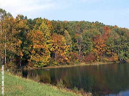
This trail begins near the Yellowwood Lake dam, and a quick jog to the top of the dam is certainly worth the time.
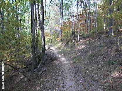
I enjoyed hiking the Scare-of-Fat Trail; it had a nice mix of level ground and hilly terrain.
Most of the time you are under the trees which makes it very peaceful. Because it was windy that day, I not only saw gentle showers of leaves but quite often heard the patter of acorns hitting the ground. Occasionally, you find some open spots with nice views.
You do have to share the trail with horses sometimes, but I didn't mind. (Do watch where you step though).
All-in-all, I recommend this trail for any weekend hiker looking for a pleasant and fairly private time in the woods.
High King Hill Vista Trail
This is a very steep trail which does level out after 10--15 minutes of hiking. The effort is definitely worth it; you are rewarded with a nice view of Yellowwood lake through the trees.
The trail connects with the Scare-of-Fat Trail, so you can continue hiking if you want or just reverse direction and head back. Horses are not permitted on this trail, but I did see more people here than on the Scare-of-Fat Trail.
All-in-all, I recommend this trail for a quick jaunt into the woods. Be prepared for some really steep terrain at first though.

Mark Tarrant
This Description is from Carol Polsgrove, 2005
Yellowwood Lake: "L" trail on the west side of the lake--the opposite side from the campground area--is a lovely trail, level more often than not but with a few dips. There's a long stretch of pretty mature forest without thick understorey, so you can see through the trees to the lake for most of the way. I had the trail all to myself the summer morning I walked it. There' s one point (about 3/4 of the way to the north end) where you can stop right above the lake for lunch or a snooze. If you go in early-mid August, watch for a big patch of pink hibiscus growing by the edge, and the butterflies the hibuscus attract. The end of the lake is full of waterlillies. You can apparently continue on "L" all around the lake, though the eastern side appears to be inland and not on the lake, so I just hiked back the way I came. The state map says the full "L" loop is 4.4 miles. I'd estimate going just up the west side and back again at not more than 4 miles total. The trailhead on the south side is at the west end of the dam. You can get to this point from Yellowood Road or you can get to it by following a not very good trail around the end of the lake from the boat ramp. If you'd rather boat, you can rent a rowboat at the campground and go up the lake that way.
| National Forest |
|---|