Terry Brennan Marsh
Location: From Plymouth, take SR 17 west; where it turns south, turn north a quarter mile to West 9C Road (yes, "9 C"). Turn left here and go a mile and a quarter to South Tulip Road; turn left and go about half a mile until the road crosses a stream. Park a bit farther south, then walk back north past the creek and head into the Menominee Wetland Conservation Area; keep sloshing west another quarter of a mile and you're in the marsh.
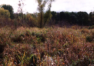
Description: A marsh-lovers' marsh. "Wetland" doesn't do it justice; this place is
drenched. Just north of the bridge is some higher ground, mostly oak savannah; unless you're wearing hip-boots, use this to head west toward the marsh. It doesn't do you a lot of good, though; as soon as the woods run out you're in some of the roughest slogging I've ever done over "flat" land. The ground is a series of hummocks with soggy bits in between. Look for the deer trails and follow them. There are some interesting reeds and sedges here, and I would guess there are times when it would be of extreme interest to birdwatchers. The connected Menominee Wetland Conservation area is split up a bit, but contains over 800 acres in all; you could spend some time here.
.
Nearby Points of Interest: Bass Lake State Beach and Tippecanoe River State Park not too far away. Also check out Ober Savanna.
Cautions: Wear them boots (and tie them tightly).
Ownership: Nature Conservancy and Indiana DNR (Menominee WCA)
| National Forest |
|---|